Norway has long been a desirable location for the mountain enthusiast. One only need to add the word ‘Norway’ to a Google search engine, and you will be rewarded with photos that make the jaw drop.
At roughly 33% bigger than the UK and 1/3rd the size of USA, one begins to understand the scale of this Scandinavian country and its 5.3 million inhabitants.
Just think about it, Norway is 33% bigger than the UK, but the UK has 66.6 million inhabitants…
Needless to say, outside of Oslo (681,000), Bergen (271,000) and other key locations such as Trondheim and Stavanger, open space and amazing landscape is available for all to explore.
In a series of articles and posts, we intend to introduce you to the magic of Norway.
Norway is the longest country in Europe and therefore, travelling anywhere is not a quick process. It has 60.000 miles of coastline, towering mountains and dramatic fjords. Remarkably it has 2-300 peaks over 2000m+, Galdhøpiggen the highest at 2469m closely followed by Glittertind at 2464m. There are over 1000 peaks over 1650m, so, if you love mountains, Norway should be at the top of the ‘to-do’ list!
We started our articles with HARDANGER which you can read HERE.
The list will grow as we progress through Norway, but expect posts on:
- Stavanger
- Senja
- Tromso
- Lofoten Islands
- Romsdal
- Lyngen
- Svalbard
- And more…
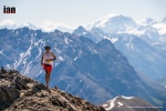
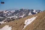
JOTUNHEIMEN

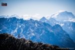
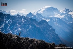
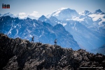
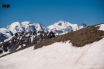
The ‘home of the giants’ contains the 29 highest mountains in Norway, and as such, it is a playground waiting to be explored. It has 250 peaks over 1900m! Established in 1980, Jotunheimen National Park covers more than 1,000 square kilometers of Sogn og Fjordane and Oppland counties. Reinder, elk, mink and wolverines live in the park and most certainly, in the more remote and quiet areas, it is possible to have a sighting.
In terms of distance and travel, the entry to the Jotunheimen region is roughly 4-hours of driving from Oslo or Bergen.
The area is vast with a multitude of possibilities and therefore, this article will be very much be a ‘part one’ to be followed up with additional posts as we explore more of the area.
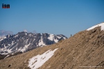
It is a popular area and in the months of June, July, August and September, you can fully expect routes to be popular with hikers, climbers and tourists. July and August being the key months due to more stable weather. However, June is a wonderful month as snow can linger on many routes.
Any visitor to Jotunheimen, particularly on a first visit, will have the iconic Besseggen top of the list along with the highest peak in Norway, Galdhøpiggen at 2469m. We will include both of these here in this article and introduce you to other options: Knutshøe, Surtningssue and Besshø.
PRACTICALITIES
First and foremost, this is an introduction to Jotunheimen, and we hope that you will read this article, digest the information and then plan your own adventure.
Jotunheimen is expansive and in all honesty, best travelled on foot.
DNT – CABINS
Jotunheimen has a plethora of cabins (DNT) which link all the major trails and routes and certainly, the DNT option provides the easiest and most logical way to link routes for an amazing multi-day experience. There are 550 cabins in Norway looked after by The Norwegian Trekking Association. There are different cabins: staffed, self-service and no service.
- Staffed – Staffed lodges serve breakfast and dinner. Many have showers and electricity, either from the power grid or from a local generator.
- Self-Service – The self-service cabins are equipped with all that trekkers need for cooking and sleeping. Firewood, gas, kitchen utensils, table linen and bunks with blanks or duvets and pillows (hut sacks, also known as hut sleepers, are required!)
- No service – No service cabins usually have the same equipment as self-service cabins, but they have no provisions. There also are a few simpler no-service cabins where you’ll need a sleeping bag and perhaps more equipment.
Use ut.no here for what is available, there is also a very good phone app.
If you plan to use DNT it makes sense to become a member as you will save money, join here.
In nearly all cases, particularly in high-season and for popular routes, booking ahead (here) is a good idea. But rest assured, DNT will never turn you away, ‘…but everyone who comes to a cabin will have a place to sleep, either in a bunk or on a mattress on the floor.’ A 2020 price list is available here. A full board option is a great idea as you get a bed, 3-course dinner (always excellent), breakfast and a packed lunch. So, if moving from DNT to DNT you can really travel fast and light and make the most of the days. NOTE: You do not need a sleeping bag, just a sleeping bag liner – great for weight saving!

WILD CAMP
Jotunheimen is a paradise for wild camping, so, if you are on a budget, looking for a raw experience or want to fastpack, this is the place for you. In most cases, you can camp close to or at a DNT cabin. So, it can be possible to save on lodging and still eat at a DNT. Especially useful if venturing out for multi-days, that way you can really save on food weight.
Screenshot of DNT meal prices:

HOTEL
Hotels are in abundance in Jotunheimen and they provide an option to be used as a base or as stops as one travels around. They are great as a start and end to a holiday in this area, but not the best option if you really want to explore.
OVERVIEW

Bygdin is perfect entranceway to Jotunheimen and you could start the journey with a little luxury at the Bygdin Fjellhotell. It is also possible to wild camp in this area, even close to the hotel. Located at the end of Bygdin lake, it’s a perfect start point.

This fjord has a ferry which you can use to access Torfinnsbu or Eidsbugarden – both of these provide great start points for a fastpacking journey.
Fastpacking Journey:
Although not discussed in-depth this article, you could leave your car at Bygdin, take the ferry to Torfinnsbu then take the trail to Gjendebu. From here you could then head north via Storådalen, Urdadalen and then to Spiterstulen which is the gateway to Galdhøpiggen. You could then climb Galdhøpiggen and return to Spiterstulen. From here, proceed to Glittertinden, on to Glitterheim and then follow the trail down to Gjendesheim via Tjørnholtjørna and Russa. From Gjendesheim take the trail via Vargebakken and Valdrersflya to arrive back at Bygdin Fjord. GPX here.
Fastpacking Hints ‘n’ Tips HERE

Route Extension:
From Gjendesheim you could take the ferry to Gjendebu (you were here on day 1 or 2 of the fastpack) and now follow the trail to Memurubu. At Memurubu you have several options? A great day out is to take the trail to Surtningssue summit heading out on the lower trail that passes Memurudalen. At the summit, return via the way you came and then the trail splits and you can return to Memurubu via different route (full details listed below). From Memurubu you can now take the Besseggen route (details below) to Gjendesheim.
Proposed Trip:

As mentioned, Jotunheimen has many options and while the above fastpacking route and option is probably the ‘ideal’ way to explore the area, we wanted to break options down into manageable junks.
Areas to explore:
- Knutshøe
- Galdhøpiggen
- Surtningssue
- Besseggen
- Besshø
Schedule:
- Day 1 – Travel and overnight at Bygdin area.
- Day 2 – Knutshøe route and then drive to Spiterstulen (2 hours) to either wild camp or stay at the DNT hut.
- Day 3 – Climb Galdhøpiggen and then drive to Gjendesheim to stay in the DNT or wild camp.
- Day 4 – Take the first ferry from Gjendesheim to Memurubu. Pitch tent or check-in at DNT and then do the Surtningssue route. Overnight at Memurubu.
- Day 5 – Besseggen ridge to Gjendesheim – You can send luggage/ tent on the ferry so that it will be at Gjendesheim when you arrive from the trek. Overnight in either DNT or wild camp.
- Day 6 – You can either travel home OR add an extra day with the climb to Besshø and return to Gjendesheim for an additional overnight wild camp or DNT.
- Day 7 – Travel
Please note:
Make sure you book the ferries in advance here. They get very busy, particularly the first one from Gjendesheim. If you have a car, you need to stay at the Reinsvangen ‘Long Stay’ car park (here,) make sure you pay for parking to cover the duration of your stay. A shuttle takes you to the ferry or you can walk, approximately 1.5 miles. When possible, book the DNT’s you require in advance.
THE ROUTES
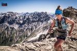
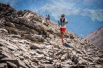
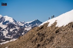
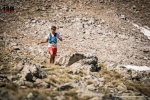
Knutshøe

A short drive from Bygdin, Knutshøe is a great introduction to Jotunheimen. Many consider Knutshøe a more challenging route than Besseggen? However, it is very much considered the younger brother or sister.

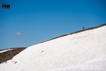
The total route is approximately 12km taking an anti-clockwise loop. You reach a high point of 1517m and in total you will accumulate 700m +/- while covering the distance. It is rated as ‘difficult’ and without doubt, it does have some exposure. Depending on experience and speed, the route could take up to 6-hours. However, moving fast and light and combining running and hiking, it is easy to complete in well under 3-hours. All the difficulty is in the first half of the route when you climb up and then descend. Once down, you have a flat 6/7km valley to cross back to where you started. GPX here.

Access to the route is from the main road and there is a small parking area that can accommodate approximately 20 cars. It is possible to wild camp here too. Either way, arrive early and start the route as soon as possible.
Note! If raining, this is NOT a good route to take. There is a considerable amount of rock both up and down and it can become very slippery.
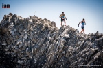
Leaving the car park, follow the trail and when at a fork, go right and head up the climb. The route requires scrambling, some climbing and at several points you will encounter steep drop-offs.

Depending on experience, you may find some areas of the route really rewarding or terrifying. It is not a very difficult route; however, it does demand respect and patience.

At all times, the views are spectacular and ahead of you, on the other side of the lake, you have Besseggen completely in view pulling you in.

At the summit, you have a wonderful 360 view and if timed correctly, you will be able to see the ferry boats going back and forth on the lake below.
The descent is rocky, challenging and requires patience. Make sure hand and foot holds are secure and take your time.
 Rock eventually becomes trail and before you know it, you will be at the bottom and next to the Gjende river. It is now possible to get water if needed?

You now go left and follow the trail back. At times, it’s easy to lose the trail so be attentive, as a recommendation, stick with the tree line and not the river. Your feet will get wet, guaranteed!
Once back at the car, take time to rest, change clothes and then make the 2-hour journey to Spiterstulen. En-route, there are possibilities to stop and buy food/ supplies.
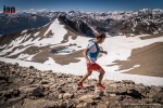
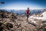
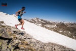
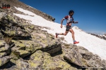
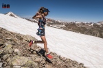
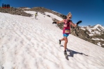
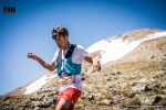
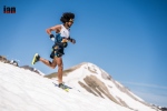
Galdhøpiggen

The drive to Spiterstulen brings you straight to the start point for Galdhøpiggen. Having the journey out of the way allows for good recovery in the evening and an early start the next day. As mentioned, you can stay at the DNT or wild camp in this area.

The highest peak in Norway (2469m) and Northern Europe is understandably a huge draw. For many, they take a guided trip leaving from Juvasshytta mountain lodge (1841m.) Guides take groups across the glacier. The glacier of course sounds appealing… However, it is an easy route with far too many people.

The route from Spiterstulen mountain lodge may not contain a glacier, but the 1400m vertical climb offers far more challenges. Especially if one travels in June as snow will still be present. The route is up and down is via a well-marked trail, GPX here.

Considered demanding, the route can take 8-hours plus, again, we completed the route in half the time.

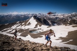
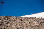
During the adventure, you will scale two peaks, totaling over 2,000 meters in height, Svellnose 2272m and Keilhaustopp 2355m! The terrain is tough and requires concentration at all times. Made up of rocks and boulders, for much of the time you are constantly piecing together a jigsaw puzzle to find the best route through. In wet weather, the route is very dangerous. Remember to follow the red “T”s that indicate the trail.

At times, you will cross snowfields and of course, stick to well used routes. Take no risks on the snow!
Several points can take you very close to the edge of the ridge. At all times be attentive, not too much of a problem in good weather, but in poor visibility you need to make sure of the route.

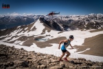
As you go up you feel several times that the summit is ahead only to reach a peak and then see several more in the distance. The final push becomes obvious as a hut is at the final summit and you will probably see a stream of people coming in from the right who have crossed the glacier.
At the summit the views are magnificent and well worth all the effort. An early start may well guarantee you some quiet time and space.

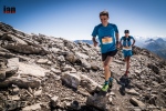
You descend via the way you came and in all honesty; due to the amount of rocks, it may well be more difficult to go down? Certainly, if you have tired or sore knees, you will feel every meter of the 1400m.
The route out and back is approximately 14km.
If you had an early start, you will be back by midday/ early afternoon and then you can take the 2-hour drive to Gjendesheim.
At Gjendesheim you can stay at the DNT or wild camp. This allows you a good night so that you can get the first ferry the next day.
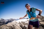
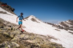
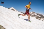
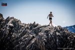
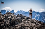
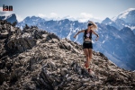
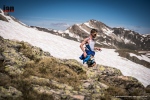
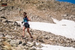
Surtningssue

Make sure you have a place booked on the first ferry from Gjendesheim to Memurubu. This is typically 0745 arriving at 0805.

On arrival at Memurubu you can pitch your tent (got to cabin and pay) or go to the cabin and check-in for your booking. Note, the cabin here is not a DNT and we recommend you book here.
Once ready, you can then start the Surtningssue route. This, in our opinion, is a hidden gem and is often neglected as Besseggen takes all the glory.

At 24km long, it’s a great day out that offers many challenges and importantly, you will see hardly any other people. On our trip, we saw nobody.
Leaving Memurubu the route is clearly marked. Make sure that you branch left when the opportunity arises. This will provide you with a clockwise route to the summit at 2368m and then back to Memurubu via a different route.

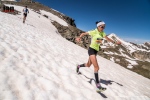
The first 8km’s are single-track trail that is very runnable. The views are stunning and only get better as you move up the trail. One advantage of experiencing the trail in June is lingering snow.

Once through the valley you start to head east. It is definitely worth having the GPX route (here) available either on a phone or watch so that you can stick with the route. Although marked, it has considerably less markings than other routes and often you are following stone cairns.

From 8/9km the route now winds up to the summit through rocks and boulders. Care is needed! At approximately 11km the trail will split with a very clear red sign showing a left and right option. This is where you go left to the summit. On your return, this is the place where you split and take the ‘other’ route back to Memurubu and therefore creating a loop.

The trail up is now steep with several false summits. You will finally see a stone hut that is open and available for shelter if required. The final push to the summit is approximately another 200m. For those in the know, they say the summit provides the greatest view and panorama of Jotunheimen.


It’s exposed at the top, airy, with plenty of potential hazards, so, take care.
The descent is via the same route until you reach the red marker. Now you veer left. Once again, the terrain is challenging as there are countless rocks and boulders.

For most of the way, the route is well marked until the final km’s. We lost the trail but could see Memurubu ahead and therefore self-navigated back to the cabin.
This route is a stunner. We felt alone and isolated. We saw nobody and encountered wild reindeer with their young.
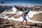
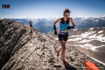
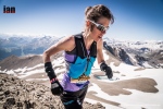
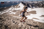
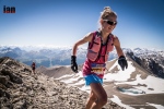
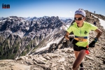
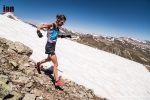
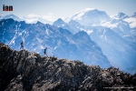
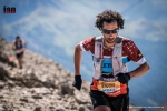
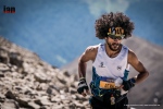
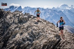
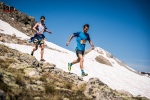
Besseggen

Besseggen is a classic ridge that ‘must’ be done. Some Norwegian’s say that you cannot be Norwegian until you have done the route. It’s a point-to-point route, so, plan ahead and send any luggage/ tent with the ferry boat. They will have your luggage waiting for you after the trek at the ferry port in Gjendesheim.
At 14km long, with approximately 1100m of vertical gain it may not appear to be a too demanding route? However, many consider it is! Many take 8-hours to do the route and 10/12-hours is not unusual. GPX here.

For perspective, there is a mountain race that takes on the exact route and the course record is an unbelievable 1hr 15min 40sec by Thomas Bereket. Trust me, if you experience this 14km point-to-point, you will wonder (continuously) how is it possible to run this so quick? Kilian Jornet ran the race in 2016, along with Thorbjørn T. Ludvigsen, Kilian won in 1.17.54.

We completed the route in 3-hours 30-minutes and that was with many photo/ video stops.

The route is very, very popular and we therefore recommend you start early. One advantage of running and fast hiking is you soon catch anyone ahead and trust me, you want to be alone as much as possible to experience the trail and views.
All this who stay at the cabin or camp will start (usually) before 0800 and then the first boat arrives at 0805 releasing another wave of people.

Characterized by the colourful emerald Gjende and deep blue Bessvatnet lakes, Besseggen ridge splits the landscape. It’s dramatic and bold and in wet weather, treacherous, so be careful!

Leaving Memurubu the trail immediately rises up and twists, mixing rock and single-track. It’s a fun trail and the first plateau already provides great views. You will pass Bjønbøltjønne lake, a good opportunity to get water if needed? Continuing up, eventually another plateau arrives and now you have a stunning view of the Besseggen ridge. It’s quite intimidating. To the right the Gjende lake and you will clearly see Knutshøe which looks fantastic.

The trail now drops, it is steep in places. Bessvatnet lake (1374m) is to your left and you walk along its edges with Besseggen looking down on you.

Bandet ridge is a significant point with approximately halfway covered and Besseggen the next challenge.

Rising 300m, Besseggen (in my opinion) is less intimidating when climbing, however, there is plenty of opportunity for exposure. It’s relatively steep but there are plenty of foot and hand holds. It’s worth stopping many times for photos. The views are remarkable.
The steepest section comes towards the end but does not last long and then you are on a plateau that gently and continually rises to Veslfjellet (1743m) which is the highest point.
The trail is now very flat and after about 1 kilometer you reach a trail junction. Follow that trail to the right down towards Gjendesheim. The route now twists and bends. Follow the markers and in here the trail is steepest with many rocks. Take care, they can be slippery, even in dry weather.
Gjendesheim ferry finally comes to view and then the final 1 or 2km is easy to the finish.
If you sent luggage with the boat, it will be available under the wooden shelter at the port. A shuttle bust will take you to the car park for the journey home.
Or, you may wish to wild camp or sleep at the cabin and the following day tackle Besshø.
Besshø

At 2258m, Besshø is 500m higher than Besseggen and it is a trail that sees little foot fall. In many respects, it is like Surtningssue and as such, it has a huge attraction.
From Gjendesheim it is an out-and-back route of 22km with 1300m +/-. It’s a route that could take 12-hours but if moving fast and light, sub 6-hours is perfectly achievable.
The route starts with the end of the Besseggen route but instead of turning left for Besseggen, you veer right in the direction of Russa/ Glitterheim.

Bessvatnet lake will appear on the left and eventually you will cross a small bridge in the eastern corner. Cross the river you will see two small cabins on the left, now follow the trailer 2 to 3 miles north on flat/ boggy trail. Besseggen will be on your left and at the far end of the lake is Bandet which you crossed just before climbing Besseggen.

Look out for the right turn that leads to Besshø summit. The climb is at times demanding and marked with stone cairns which often disappear. It’s easy to lose the route so it’s advisable to have a GPX available (route here). Depending on the time of year, you may need to cross snow fields – care needed. The route is very rocky and strewn with boulders of different sizes. Many are loose, so, caution is required. It’s a challenging route but visually stunning.

The return route is via the way you came.
RECOMMENDATIONS
Never underestimate the mountains and the environment in which you are exploring. June in particular is the start of the hiking season and as such, snow can be a factor on all of the above routes. This adds an additional potential for injury and problems. Particularly as the snow is melting and this can create snow holes, snow bridges and crevices. Do not take any risks and follow established routes and existing footprints.
It is definitely worth carry Micro-Crampons as a safety measure, particularly in June and September. Also, trekking poles are a great addition but not essential.
Make sure you check in with DNT cabins for all the routes and check conditions to make sure that you have no surprises.
Weather is crucial and many of the above routes would become very dangerous in wet weather. Rocks and boulders in Jotunheimen are everywhere, when wet, they can be treacherous. Boots are always recommended for hikers but if moving fast and light, top quality mountain running shoes are perfectly acceptable on experienced feet. I cannot emphasize enough that grip is essential! You need an outsole that works on wet and dry rock. Running shoes are very personal but recommendations are VJ Sport MAXx and XTRM, Scott Supertrac RC2 and inov-8 Roclite.

It may be 30deg next to the fjord and glorious sunshine, but at the summit, it can be below zero, blowing a gale and torrential rain. You must take personal responsibility and be prepared for all conditions. At a minimum please take:
- Suitable pack
- Hat
- Gloves
- Warm insulated layer
- Warm trousers
- Waterproof jacket/ pants
- Food for the duration of the hike and some contingency
- 1,5 ltrs of water (which can be replenished on all the routes via streams/ waterfalls)
- Take water purification tablets as a just in case and consider a water purifier such as MSR Trailshot (here)
- Map/ Compass
- Charged mobile phone with a suitable App such as ‘Footpath’ (here)
- Cash/ Card
- Garmin InReach or similar
- Bivvy bag
- Sunglasses
- Sun cream
Plan your routes, be realistic on timings and always start early. One of the huge advantages of outdoor activity in Norway is daylight. In June, July, August it is light at 0300 and goes dark after 2200 hrs.
CONCLUSION
Jotunheimen is to mountain lovers, what Disney is to fair ride lovers.
It’s a playground of trails, routes, summits, views, experiences and wildlife all wonderfully interconnected with marked trails and DNT cabins.
This article is created as a gateway to the area knowing only too well that it will whet your appetite for other adventures.
As mentioned at the beginning, the best way to explore this area is by foot and we are sure that once you have followed our weeklong adventure above, you will already be planning to return and explore.
In comparison to our first Exploring Norway article on Hardanger, I would consider Jotunheimen a more challenging environment, so please consider experience and fitness when contemplating any of the above routes.
We cannot emphasize enough the role of weather and the impact it has on all of the above recommendations. The mountains will always be there, cancelling a planned route or turning back is acceptable and wise.
PERSONAL NOTE
Special thanks to Abelone Lyng who has extensive knowledge of Jotunheimen. Her experience was invaluable in planning routes and making a workable itinerary.

Please support this website. I believe everyone deserves to read quality, independent and factual articles – that’s why this website is open to all. Free press has never been so vital. I hope I can keep providing independent articles with your help. Any contribution, however big or small, is so valuable to help finance regular content. Please support me on Patreon HERE.
![]()
Follow on:
Instagram – @iancorlessphotography
Twitter – @talkultra
facebook.com/iancorlessphotography
Web – www.iancorless.com
Web – www.iancorlessphotography.com
Image sales –www.iancorless.photoshelter.com